Blog

Operator Success – Now Meters Drilled vs. Rig Count

Canadian's have typically measured success in the Oil and Gas industry by the number of active rigs, or rig count throughout the year. With long stretch horizontals and deeper formations such as the Duvernay, Montney and Wilrich, operators are utilizing less rigs, but with these rigs have increased to record numbers is the Total Meters drilled.

As charted by the Daily Oil Bulletin:

  • The biggest increase for meters drilled was seen in BC with an increased meters drilled of close to 20% over 2012

    • Progress Energy has proven to be one of the major factors for the increase in this Western Province

  • Western Canada so far overall with a 3.62% over 2012 numbers

    • 21.11 million meters vs 20.37 million meters

With deeper drills and longer laterals comes the expectation for increased production, also increasing the risk of each well to the operator. Many operators are turning to new techniques as well as gaining further information in the laterals to help identify the best completions strategies for their play.

With Cordax's Logging While Tripping system, open-hole logs can be obtained safely and more cost effectively in any HZ well. In turn, this will give the operator a cost effective solution to ensure maximized production from these wells.


Dunvegan Formation – Growth Opportunities Utilizing New Technologies

Until a few years ago the Dunvegan was a relatively unheard of play. Seems that the times are changing and a number of Western Canadian producers are gaining success drilling it. It does not have the same size and scope of a true resource play as it is limited in areal extent and has variable reservoir thickness. On the contrary it is an interesting play. It shows you where you can apply new technology to get the most of your investment.

Numerous companies, especially those in the Kaybob area of northwestern Alberta, have been taking advantage of technological advancements in horizontal drilling and multi-stage hydraulic fracturing to fully exploit light oil reserves from the Upper Cretaceous sandstone formation. It's a real emerging hot play as these active Canadian producers can attest:

  • Tangle Creek

  • Apache Corporation

  • Trilogy Energy Corp.

  • Mancal Energy Inc.

  • Progress Energy Resources Corp.

  • Canadian Natural Resources Ltd.

  • ConocoPhillips Canada Operations Ltd.

The Dunvegan shows a lot of promise for the oil and gas industry. It's not a huge play, but it can be quite an attractive play.  The formation consists of a variety of sandstones in deltas and channels that are easily mapped and maintain continuity. The sandstones originally came from way up in the northwest in northeastern B.C. and the Territories. They sort of reach a limit in west-central Alberta, around Kaybob, Waskahigan, Fox Creek and areas like that. The producers can get some pretty good oil out of there, and its good-quality oil. It's light and it's sweet, and it's in an area that is great for infrastructure that can bring overall costs down.

The Dunvegan targets are quite attractive for producers to search after, extensive drilling in the deeper targets gathered a lot of information on them, because there are so many different drilling targets in those areas - from very shallow formations like the Cardium, down through a lot of the deep ones including the Montney and Duvernay plays that are very hot right now.

Although the play is hot right now a huge land rush is not anticipated. Most of these lands are already held for deeper zones, so as companies go in and do their drilling for their Montney’s and Duvernay’s and other things like that, they'll stumble across these smaller Dunvegan sands up-hole, and if it looks promising they'll do some more mapping and they might be able to make independent little projects out of them. The industry has known about the possibilities of the formation for some time, until horizontal drilling and multi-stage hydraulic fracturing technologies became more advanced, the prospects of developing the Dunvegan were fairly limited even in the area of Alberta where it now presents a promising resource.

As this play emerges Cordax's LWT system has been helping operators in the Dunvegan gather open hole logging data that can be obtained safely and more cost effectively in any HZ well. This allows full optimization of these new completion techniques to get the most out of every well.

Cordax LWT can help your next Dunvegan well by:

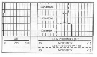
  • Recognition of changing reservoir quality such as porosity or fluid content

  • Measurements of resistivity with minimum invasion

  • Revealing faults early enough to react to potential problems

  • Detection of fluid boundaries

  • Replacement of pilot holes (save days of rig time)

  • Frac and completion optimization

  • Mapping of sweet spots


The Montney – An Introduction

The Montney Formation is 240 million years old and formed in the early Triassic period. It is situated below the Jurassic/Cretaceous Doig Formation and above the Permian/Carboniferous Belloy Formation.  The Montney ranges from Fort St. John, BC and extends to the south-east toward Fox Creek, AB.   The north-west region is typically considered "shaley", predominantly "silty" in the  Dawson Creek area, and coarser toward Valleyview and Fox Creek.  Drilling depth to the Montney follows the same trend in grain size, shallower in Northwest and deeper in the Southeast.  The Montney reaches a maximum thickness of ~280 m (920 ft).

What Does It Look Like?

The Montney formation is not a "true shale" due to its high composition of siltstone, but rather considered as a "hybrid", due to the higher content of siliciclastics. Interbedded in the Montney are highly radioactive phosphate layers that can be correlated over much of the Northeast British Columbia basin. These phosphate layers are believed to be the result of rapid rise in sea level, resulting in organic rich layers being deposited over top of fine grained sand and siltstone. These cycles repeat, resulting in a Gamma Ray reading that varies from 150 API to <75 API.  Below is an example of a well log showing the distinctive change from the Doig Formation to the Montney.

Oil & Gas Production

Oil is produced from the Western Alberta region of the Montney, where it presents a coarser sandy facies. Natural gas is produced from the gas rich silty shale occurring in the North-Western borders and Dawson Creek/Pouce Coupe Areas. It is estimated that the Montney contains over 50 trillion cubic feet of natural gas.

Shale gas extraction emerged in the late 2000’s where previously it was difficult and uneconomic to produce due to the low permeability. With advancements in hydraulic fracturing and horizontal drilling, reliable and affordable production of natural gas from shale resources is attainable. The chart below outlines the highest gas producing shale formations. Notice that the Montney is 3rd with reserve estimates in excess of 300 trillion cubic feet.

Future Exploitation

The application of horizontal drilling with aggressive build sections has allowed the borehole greater access to target reservoirs. The utilization of horizontal drilling applications with open hole evaluations and multi-stage fracture sequences and has helped show the lucrative potential of the Montney Formation.

Wilrich – Alberta’s Deep Basin Natural Gas Giant

Recently recognized as the most economic gas reservoirs in Alberta’s deep basin "The Wilrich continues to rank as one of the most active and fastest growing plays in the Western Canadian Sedimentary Basin (WCSB)," said Peters & Co. Limited.

As expected, oil and gas giants such as EnCana, ConocoPhillips, Husky and CNRL own land within this region. That being said, the main players currently taking advantage of the formation include:

  • Peyto Exploration

  • Tourmaline Oil Corp

  • Westbrick Energy

  • Santonia Energy

From the ~250 wells currently drilled into the Wilrich, it is said that the total natural gas volumes is currently at 0.42 bcf/day.

  • Tourmaline expects to drill 45-50 Wilrich wells in 2013

    • Initial prediction was 4.5-5 bcf wells, and they are currently exceeding these expectations.

    • With this success and well costs coming down due to knowledge of the play, 6 rigs are running for them with a pad drilling program that will help drop costs even more.

Despite the fact that gas wells aren’t thought to be sought after as much as oil at this time, the Wilrich has shown to have a breakeven point of $2/mcf and still maintaining economic numbers as low as $3/mcf.

The composition of the Wilrich member, pre horizontal drilling, was thought of as tight shale that didn’t have much potential under the Fahler sand formation.  The geology has since been proven as a number of different individual sandstone and siltstone stringers containing different:

  • Reservoir compositions

  • Hydrocarbon Characteristics

  • Both Oil & Gas, depending on location

With Cordax's LWT system, open hole logs can be obtained safely and more cost effectively in any HZ well. This allows full optimization of these new completions techniques to get the most out of every well.

Quick Guide – Well Logging Interpretation


By taking a quick glance at any well log a lot can be determined about the rock. Formations/Hydrocarbons provide different gamma ray, density, neutron and/or resistivity tool responses making it easy to get a detailed look into what is downhole. Typical Sandstone, Limestone and Dolomite formations

Sandstone

  • Pe = 1.81

  • Gamma Ray <20 API

  • NPor = DPor (SS Scale)

Limestone

  • Pe =5.08

  • Gamma Ray <20 API

  • NPor = DPor (LS Scale)

  • NPor > DPor by 6-9% (SS)

Dolomite

  • Pe = 3.14

  • Gamma Ray <20 API

  • NPor = DPor (DOL Scale)

  • NPor > DPor by 12-14% (LS)

HydroCarbon (Oil)

An oily formation can be spotted typically by an increase in resistivity over a watery formation with a pinching effect on the porosity curves. This pinching effect becomes more noticeable when the logs are plotted on the correct matrix for that formation.

  • Ex. A possible oil hydrocarbon zone in a sandstone formation, plotted using a sandstone matrix as shown by the PE of ~1.8.

HydroCarbon (Gas)

A gas formation can be spotted also with an increase in resistivity over a watery formation, but mainly due to the crossover shown by porosities. The crossover is due to Gas Effect, which supresses the neutron curve due to low hydrogen content.

  • Ex. Shows a possible gas hydrocarbon zone in a sandstone formation, plotted using a sandstone matrix as shown by the PE of ~1.8.

Coal

A coal, having a great amount of bound water, creates a distinct high porosity reading on both the neutron and density porisity curves. High resistivities are also seen due to this bound water. Expected PE for a coal is very low at only 0.2.

Anhydrite

Anhydrites are typically spotted using the porosity curves. As shown below in a sandstone matrix, the neutron reading hovers close to 0% pu while the density reads -15%. Being that anhydrite is that much denser than a Sandstone formation.  PE for an anhydrite is typically close to 5.

Heavy Minerals (Barite)

Heavy minerals such as Barite area spotted mainly using the PE curve (Density tool). Being such a heavy mineral, it is very dense and has an extremely high PE of 267.

Shale

Shales are very noticeable when using both porosity curves as well as the resistivity curves. With no invasion present the resistivity curves overlay while the porosity curves spread apart. 

The spreading of the porosity curves is due to Shale Effect, which exaggerates the neutron curve due to high hydrogen content of the clay itself.

Metal Downhole

Tools such as your induction can provide erratic responses when metal is found in the hole. Casing shavings could be a cause for this type of response.

To do more in depth calculations on a given formation, including porosity matrix adjustments as well as water saturation, calculators are available.

Completions – Fracture Proppant Selection

When a well is being fractured, the high pressures cause a network of openings, aka “fractures”, throughout the formation allowing channels for the hydrocarbons to be produced. After this pressure is released these channels must remain open in order to keep the hydrocarbon production flowing. Fracture Proppants are used to take the stress from the surrounding formation, holding the fractures open, as well as allow the hydrocarbons to pass through their mesh like structure makeup.

Proppant Attributes

Proppants are typically made up of a solid material, sand or ceramic. It is added to the fracture fluid, mainly slickwater, which has become the popular choice since 2012. As shown below there are different sizes or proppants used, each having their own pros and cons.

Typical Issues when using Proppants

Formation Stresses

  • High stresses from the formations take a toll on the Fracture Proppants, especially in circumstances when a well is shut in and awaiting production. During this time Proppants can break down and create “fines” which cause blockage in the channels. Coulter & Wells (Journal of Petroleum Technology, June 1972) has done research stating “that just 5% fines can decrease fracture flow capacity by as much as 60%”.

Proppant flowback

  • Pressures from the formation while hydrocarbons are being produced may cause the proppants to “flowback” into the borehole. If the flowback is great enough this may cause the channels to close up and loss of complete production from that network.

Coated Proppants

To increase the strength of the larger sized proppants, and to ensure less “Fines” are being created, the sands can be coated with resin. This resin allows the larger sized proppants to be used, making the channels bigger in the formation, and also allowing the hydrocarbons to still pass through the resin covered proppant. Also, the resin on the coated proppants allows them to form a bond in order to minimize the amount of proppant flowback from the channels.

As studies continue on the best practices for completions of a well, there are many components including breakdown pressures, fracture fluids and proppants used can affect the production. Parameters such as breakdown pressures can be adjusted using petrophysics analysis of open hole logs. Cordax's Logging While Tripping technique allows open hole data into the lateral in a much safe, cost effective method.

Underbalanced Drilling - Logging Solution

Underbalanced drilling is a procedure used to drill oil and gas wells where the pressure in the wellbore is kept lower than the fluid pressure in the formation being drilled. As the well is being drilled, formation fluid flows into the wellbore and up to the surface. This is the opposite of the usual situation, where the wellbore is kept at a pressure above the formation to prevent formation fluid entering the well. In such a conventional "overbalanced" well, the invasion of fluid is considered a kick, and if the well is not shut-in it can lead to a blowout, a dangerous situation. In underbalanced drilling, however, there is a "rotating head" at the surface - essentially a seal that diverts produced fluids to a separator while allowing the drill string to continue rotating.

Advantages of running the Underbalanced Drilling System:

  • Eliminated formation damage from invasion

  • Increased Rate of Penetration (ROP). With less pressure at the bottom of the wellbore, it is easier for the drill bit to cut and remove rock

  • Reduction of loss circulation

  • Differential sticking is eliminated

  • Increases reservoir knowledge

Disadvantages of running the Underbalanced Drilling System:

  • Increased drilling costs

  • Possible wellbore stability problems

  • Compatibility with conventional MWD systems

  • Generally higher risk with more inherent problems

  • Possible excessive borehole

There is a way to mitigate the risk when it comes to openhole logging in underbalanced drilling scenarios.  Cordax's Logging While Tripping (LWT) is a patented formation evaluation technique in which open hole logs are acquired safely in horizontal and hostile hole conditions that you would experience in underbalanced drilling scenarios.

Understanding Resistivity Invasion Profiles

Petrophysical analysis plays an important role in the success of a company. To keep a broad topic simple I will speak in regards to the Invasion Profile caused by a resistivity tool. The petrophysicist’s knowledge, in terms of the reservoir and the migration of hydrocarbons, not only helps determine, and possibly increase, that well’s overall production, but supports future reserves in any adjacent wells that maybe in the plan for future. The invasion of drilling fluid into the rock plays an important role in this analysis.

What is Invasion?

  • Due to the differential pressure in the borehole, drilling fluid is forced into the rock, causing invasion of this fluid into the reservoir fluid

  • The distance the rock is “invaded” by the drilling fluid helps determine the invasion diameter, which makes up the invased zone of the rock

  • “Invasion profiles” can be found using conductivity measurements, that provide different depth of investigations, to determine how far the drilling fluid has penetrated the rock

  • To ensure the rocks true resistivity (Rt) is being measured the deep induction reading is typically used as the depth of investigation penetrates the furthest.

Why is Rt important?

Looking back at Archies Equation, to determine the water saturation of a formation, in addition to knowing porosity and formation water resistivity (typically found in catalogues) we also need to know the formation resistivity. Depending on how these curves react to one another helps determine what to use as your formation resistivity in this calculation.

In addition to resistivity, measurements such as porosity, natural gamma ray and spectral gamma ray are available using Cordax's unique, safe memory logging method. 


Viking – Millions of Recoverable Reserves at Shallow Depths

The Viking Formation has been recognized since 1918 as both a light oil and natural gas bearing sandstone. With the TVD depth of the Viking being the shallowest of the Light Oil plays, and new technology allowing for better recovery from tight formation, the activity level continues to ramp up.

Past Exploration (upper Viking):

  • Over 8000 vertical wells drilled since the 1950s

  • Production from the upper Viking sand estimated at two billion barrels

Present Exploration (lower Viking):

  • Advancements in technology have revealed a lower, and thicker, Viking Sand estimated at another four billion barrels

  • Horizontal drilling and multi-stage fracture techniques allow for lower costs when accessing the reserves

  • As of recent, Viking wells have been drilled, completed and equip for under $1 million

  • Quicker payouts quick due to low costs

With low operating costs in the Viking Sand it’s not a surprise to see major producers such as Devon Energy Corp., Husky Energy, Pengrowth Energy, as well as Penn West Exploration all seeking this asset. In addition to the majors, many juniors have stayed active as the risk to reward has proven to be in their favor.

Due to the low operating costs, to get a Viking well drilled and to the production stage, the Recycle Ratio for this play is very attractive and will continue to be this way, even with subpar oil and gas prices. Much like the Cardium formation, expect companies to increase their activity in the Viking and let this, almost guaranteed, cash flow in.

With Cordax's LWT system, Open hole logs can be obtained safely and cost effectively in any HZ well. This allows full optimization of these new completions techniques to get the most out of every well.

Things are Heating up in the Alberta Bakken

It is the same age as the Bakken in Saskatchewan and North Dakota, but is yet to be proven the identical resource.  The Alberta Bakken/Exshaw fairway is bound by the Rocky Mountain Thrust Belt to the West, Sweetgrass Arch to the East and continues South into Montana.

This unconventional reservoir is overpressured, low permeability, and mixed lithology.  Early vertical wells were looking at the mulit-zone potential.  The Exshaw in the area had oil stained cuttings and when Drill Stem Tested recovered clean oil.  These wells also found the localized sweet spots with pay sections over 25m thick.  Faulting has created the thicker sweet spots, but more important are the associated natural fractures as they are the conduit for higher production rates.

Keys to success in this play will be:

  • Identifying extensional faults

  • Drilling near structure to increase probability of natural fractures

  • Effective completion strategies

Once drilled using data from the horizontal, well logs and gas detector to:

  • Identify the natural fracture network    

  • Find the brittle or ductile areas

  • Tailor the completion program

With the recent success of the Three Forks formation in the Williston Basin, more activity is forecast for the Exshaw / Alberta Bakken.